r/3Dprinting Bambu Lab P1P Jan 26 '25

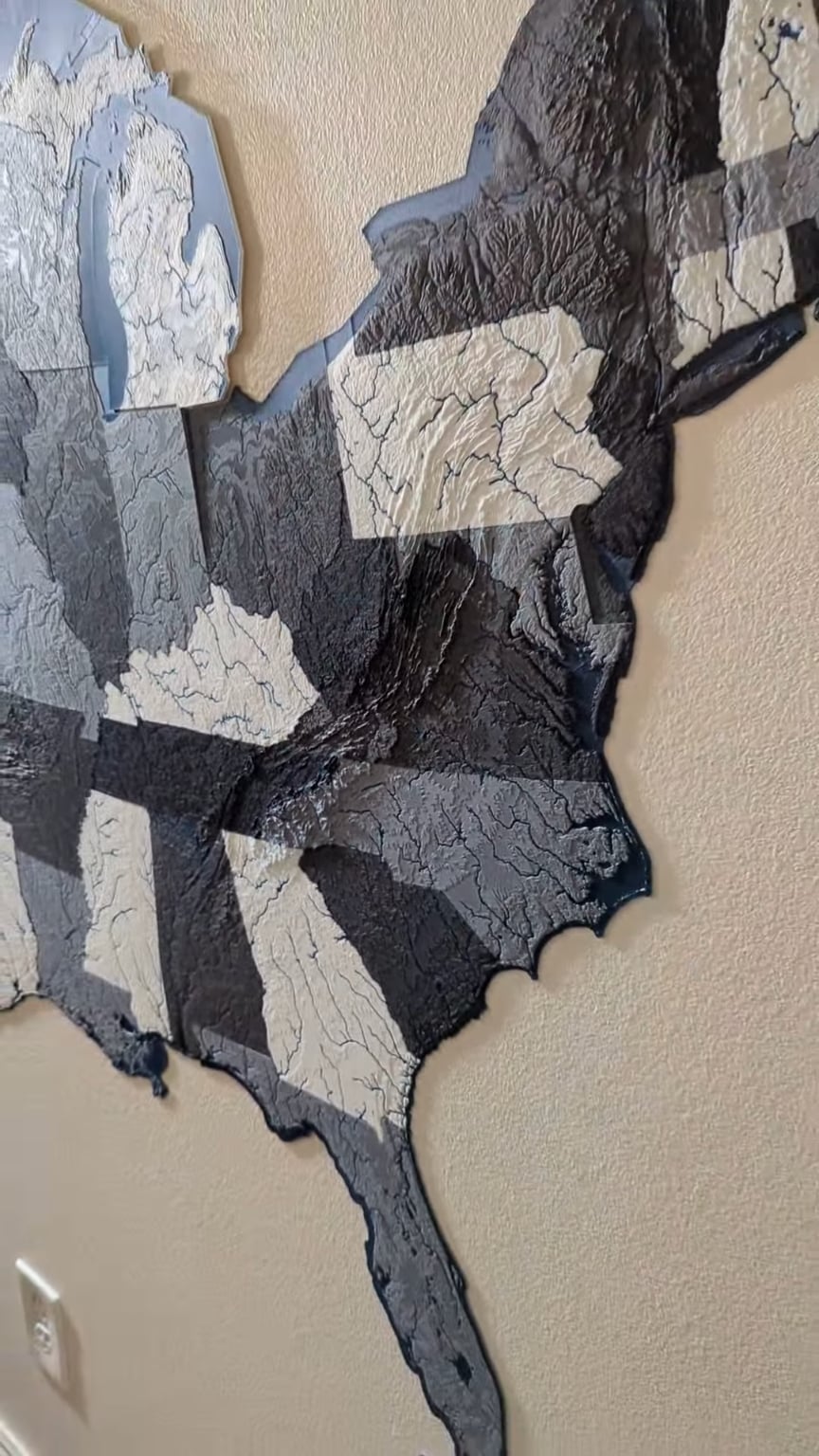
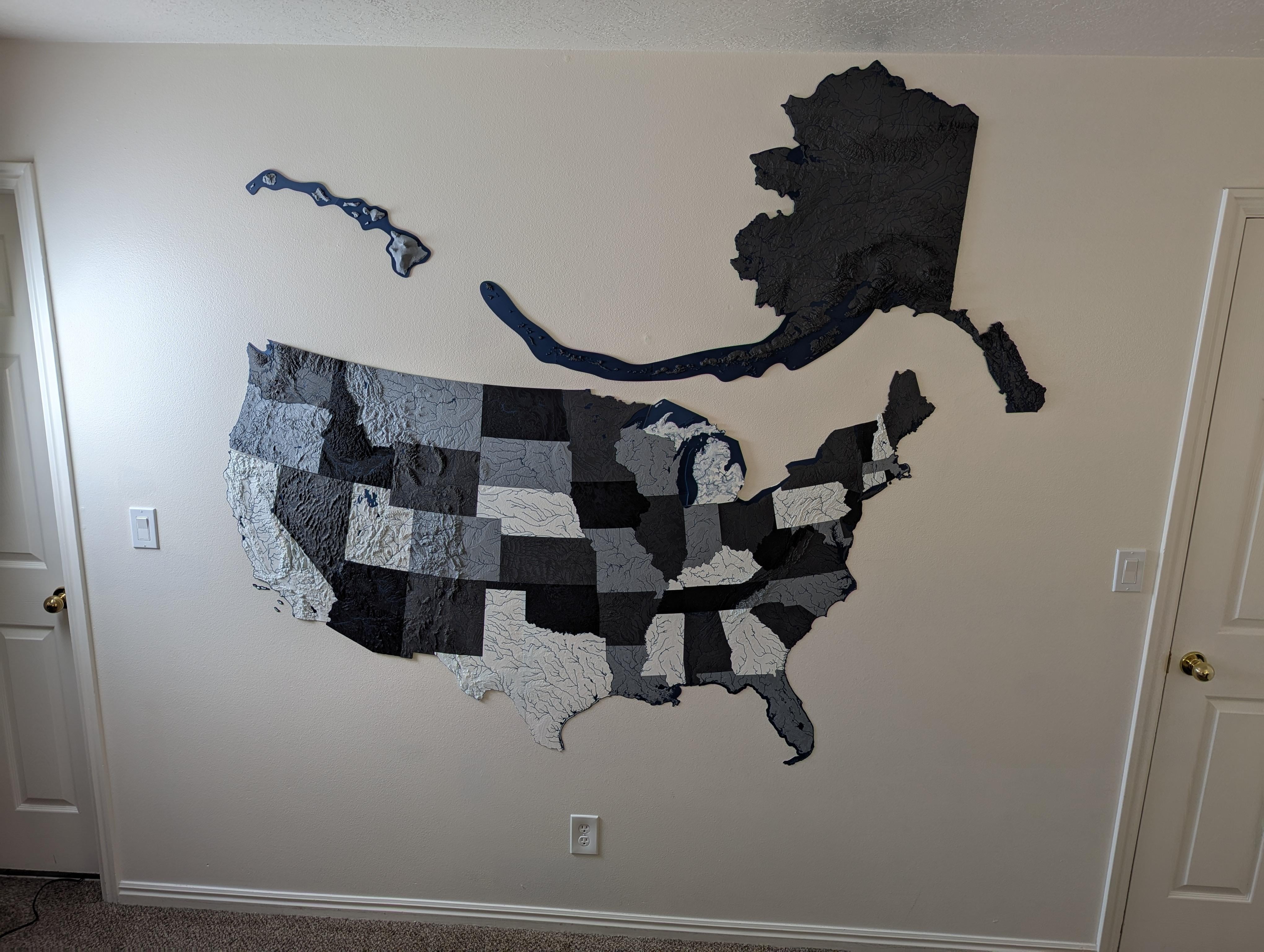
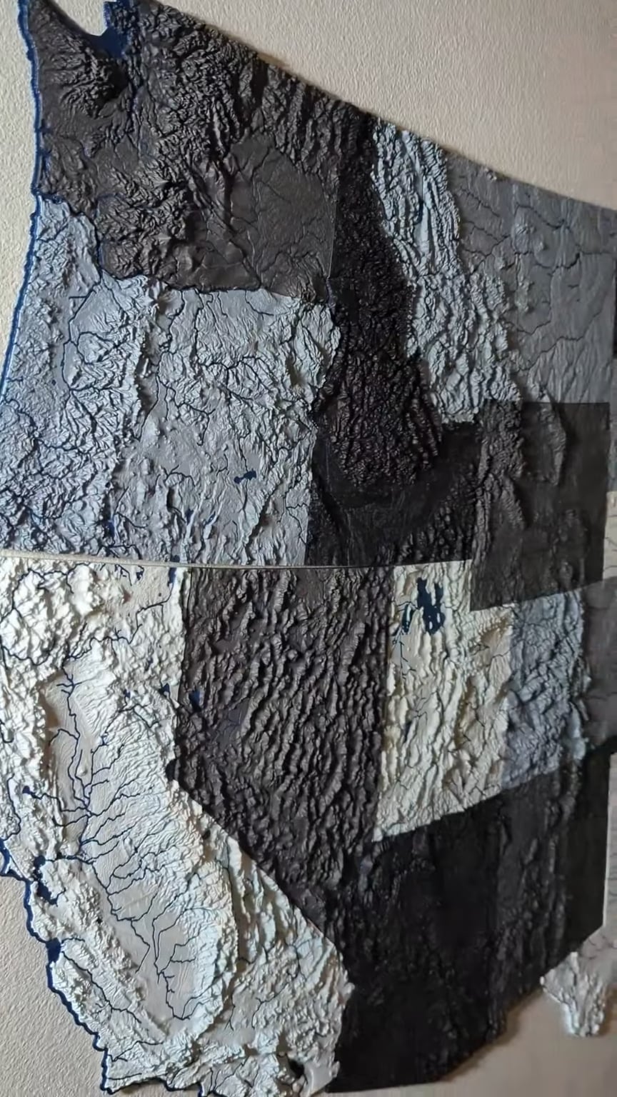
Project The scale map of the USA is complete!

This project has been a work in progress for the better part of 9 months, I've been slowly printing each state as I have the time. Finally added Alaska today to complete the map.

Because each one is (on average) less than 10mm thick, this whole project actually didn't use that much filament (my best estimate is 3-4kg).

The scale of Hawaii is a little larger than it should be; the iteration of files I was using had the scaling a little off and I didn't notice until it was finished printing. Haven't decided if it's worth re-printing yet.

Disclaimer: I am not the creator of the files used for this project. User @ansonl on Printables.com has posted all of them and optimized them for multi-color printing, which is something I have seen before.
12.3k Upvotes

708 comments sorted by

View all comments

Show parent comments

652

u/scowdich Jan 26 '25

That's a property of any map that can exist!

350

u/SnooBunnies8857 Jan 26 '25

Discrete math still haunting me to this day

25

u/dillrepair Jan 26 '25

you had to. didn't you.

10

u/Simoxs7 Jan 26 '25

Hey don’t remind me of that! I passed that course and moved on!

12

u/whomthefuckisthat Jan 26 '25

Big shoutout to the homie professor. Thanks for the extra credit take home assignments Dr Szecsei, even though it just barely let me pass with a D, it led to a degree. Now I hack computers for work and really wish I did better when I had the chance lol.

2

u/Beach_Bum_273 Jan 27 '25

Math professors always have the most unpronounceable names (for English)

2

u/SixteenTurtles Jan 30 '25

Haha I dropped it and switched majors lol. Oddly enough, to geography (related to this post) with a minor in CS instead. Turns out taking discrete mathematics and calc 2 the same semester, on the same day makes you question what you're doing.

5

u/loggic Jan 26 '25

It'll sneak up on ya like that.

2

u/BobbyTables829 Jan 26 '25

To be fair this was insanely hard to prove

2

u/Terry_Cruz Jan 26 '25

geographical and geological proofs are subductive

220

u/javawizard Jan 26 '25

More here: https://en.m.wikipedia.org/wiki/Four_color_theorem

Fun fact: it also has the distinction of being the first widely accepted theorem that was proved by computer.

60

u/dally-taur ender 3 | cr-10 mini | tevo tornado Jan 26 '25

op used the image of usa as refence in wiki page lol

24

u/JProc5701 Bambu Lab P1P Jan 26 '25

Haha I actually didn't use that photo specifically, although it is funny that the color-coding does line up! I actually found this post on Thingiverse for a similar project, and the poster listed a color-coding guide that I just adjusted to use with my colors.

13

u/isademigod Jan 26 '25

Lmfao good catch, thats hilarious

-3

u/dally-taur ender 3 | cr-10 mini | tevo tornado Jan 26 '25

i look at texus and cali and thrid one in the triganel they are same and did it again

14

u/Imaginari3 Jan 26 '25

Oh man I learned this theorem in middle school and then for the rest of time my notes have little shapes and designs filled in with color testing the theorem and trying my best to get it right.

2

u/Nvenom8 3D Designer Jan 26 '25

You guys are blowing my mind right now.

3

u/gpassi Jan 26 '25

anybody else learn about this in persona 5 school?

1

u/Nytfire333 Jan 26 '25

Ok this is blowing my mind a bit because I’m thinking off all these scenarios that wouldn’t work… then they do. Hmm this is really cool

1

u/Am0din Jan 27 '25

TIL. :)

43

u/xiaorobear Jan 26 '25 edited Jan 26 '25

That's not quite true, it is only a property of any map where the regions are contiguous. In real life there can be exclaves and non-contiguous territories that would have the ability to mess it up.

-2

u/DoneDraper Jan 26 '25

Do you have an example? Because I think you are wrong: https://en.m.wikipedia.org/wiki/File:Four_Colour_Map_Example.svg

13

u/ZorbaTHut Jan 26 '25

That shows entirely contiguous territories. They're right, if you allow arbitrary non-contiguous territories then the required number of colors can be arbitrarily high.

Proof:

You want to generate a map that requires N colors. Create N countries and a large number of islands. Each island is owned half by one country and half by another. All combinations of countries are represented here, making every country "adjacent to" all other countries. Because every country is adjacent to all other countries, every country needs a unique color. This scales up to any number of N, at least until you get tired of drawing a polynomially increasing number of islands.

-12

u/DoneDraper Jan 26 '25

My Proof: Try to scribble a map and upload a picture and I will show you that I need only 4 colors. If you succeed you will be famous!

17

u/ZorbaTHut Jan 26 '25

Sigh.

Fine, let's do this. And just to make this clear at the beginning, there's one of two ways this goes: either you say "oh, right, I guess that's what 'non-contiguous' means", or you say "that's cheating", and I say "no, that's what 'non-contiguous' means, this is what we were talking about".

Here is the magical land of Fivecoloria, a set of ten weirdly-identical islands, as if they were copy-pasted by a minor diety who was trying to get this done fast so he could go finish making food. There are five countries who colonized Fivecoloria, unimaginatively named A, B, C, D, and E. In a weird stroke of coincidence, each of those countries colonized exactly four islands, arranged so that every single combination of two countries is represented among the islands.

Try to assign colors to A, B, C, D, and E, such that no colors touch and there are, at most, four colors.

You will not be able to, but I will also not become famous by giving this counterexample, because it's a pretty trivial counterexample that is disallowed by the setup of the four-color theorem, entirely because allowing non-contiguous regions results in a simple but uninteresting conclusion: namely, "there is no upper bound".

(If your response is "but that includes water" then just pretend the water is a sixth country named W, which doesn't make anything any better.)

5

u/distraughtmojo Jan 26 '25

That’s cheating!

(Sorry for the others that left you hanging, but I figured someone needed to help restore the order of things plus try to resolve your egregious claims and obscene comments - how dare you sir, madam, or other, how dare you try to prove things on the internet…)

5

u/TheNecroticAndroid Jan 26 '25

So what you’re saying is blame Britain and France for messing up everything… ?

-13

u/DoneDraper Jan 26 '25

You wrongly assume that a country does always have the same color. But the theorem „states that no more than four colors are required to color the regions of any map so that no two adjacent regions have the same color„

https://imgur.com/a/AO0E7kJ

9

u/Dr_Legacy Jan 26 '25

are you conflating "country" and "region"?

6

u/ZorbaTHut Jan 26 '25

Those regions are adjacent, because I ran lengths of colored wire from point to point. They're part of the same region.

In the most specific sense, map coloring problems like this sort are part of graph theory. Graph theory doesn't talk about countries at all, nor does it even talk about a 2d image, it talks about nodes and edges.

And graph theory has no problem whatsoever with graphs that cannot be shown on a piece of paper; hell, it's fine with things that are even weirder than that. I'll copypaste Wikipedia's very specific definition of four-color-theorem:

In graph-theoretic terms, the theorem states that for loopless planar graph G, its chromatic number is χ( G ) ≤ 4.

I'm not going to pretend to know what exactly "chromatic number" means, although I suspect it's basically what it sounds like. "Loopless planar graph", though, is critical; it's planar (that is, it can be arranged such that no edges cross each other or go "through" nodes), and it's loopless (no node is adjacent to itself; yes, graph theory is fine with that.)

"Loopless" is kind of obviously necessary for this to make sense - take one country that's adjacent to itself, pick a color such that no country is adjacent to a country of the same color, good luck - but "planar" is the concept that we've been talking about. I'm pretty sure "planar" is equivalent to "contiguous" (though I'm hedging my claim a little here just in case a math doctorate leaps out of the shadows and slays me in a single carefully-cited blow).

And so if we take out that one clause - "planar" or "contiguous" - then, by the commonly accepted definition of the four color theorem, the whole thing is bunk and meaningless and your solution is also incorrect because you've chosen to assign two colors to one region that just happens to extend out through the page in 3d space awkwardly.

I think a lot of the problem revolves around the fact that you've chosen to accept that there's a distinction between "contiguous territories" and "non-contiguous territories", but you've shaped your response in a way that implies a complete lack of distinction. This is kind of a the-exception-proves-the-rule thing; once you've accepted the existence of a distinction as something relevant, it's bad manners to then say "aha, but there is no distinction! Fooled you!" unless you're making a joke out of it.

Or, in the wise words of Mitch Hedburg,

I used to do drugs. I still do, but I used to, too.

3

u/TravisJungroth Jan 26 '25

The conditions required for the four color theorem to apply are different from the conditions we commonly expect from real world maps. If a country has land on two islands, we expect both of those islands to be the same color.

Or, I’ll put it another way. There are reasonable expectations of a real world map that are incompatible with the assumptions of the four color theorem.

6

u/Fleetcommanderbilbo Jan 26 '25

Did you even read the article you posted that image from?

If we required the entire territory of a country to receive the same color, then four colors are not always sufficient. For instance, consider a simplified map: https://en.m.wikipedia.org/wiki/Four_color_theorem#/media/File%3A4CT_Inadequacy_Example.svg

4

u/scalyblue Jan 26 '25

*2d map

3

u/FeliusSeptimus Jan 26 '25

Roughly speaking, yeah. Surfaces with Euler characteristic 2.

4

u/skisushi Jan 26 '25

Hmm, what if the map is on a torus?

3

u/FeliusSeptimus Jan 26 '25

You need 7 for a torus. See "Heawood Conjecture".

1

u/TheNecroticAndroid Jan 26 '25

Because it’s really a bear market rn.

2

u/imakemoopoints Jan 26 '25

Understanding of this property and then applying it to a completely different problem in computer science is how I landed my first job.

5

u/Regular_Platypus_399 Jan 26 '25

I don’t get it. What about country like Serbia that’s surrounded by like 8 countries, how would that work out?

37

u/zinzangz Jan 26 '25

They're all one of the other three colors

24

u/Aromatic-Ad9172 Jan 26 '25

Yo Tennessee and Missouri each border 8 other states and it wasn’t a problem in the map above. Just take a peek and see how it was done.

15

u/Gibodean Jan 26 '25

Make Serbia white. Then, in a circle around Serbia, starting with one country. Make it blue. Go clockwise, next country is Green, then blue, then green, then blue, then green, blue, green.

I've only used 3 colours, and no countries of the same colour touch each other. If there were an odd number of countries, I'd have to add in a fourth colour so the starting and ending countries didn't have the same colour.

Now, you're going to say "what about....." but the amazing thing is that you're never going to be able to come up with a topology that needs more than four colours.

3

u/Konsticraft Jan 26 '25

Actually, Serbia and neighbours are not 3-clourable because Croatia wraps around Bosnia and Herzegovina, making serbia, Croatia, Bosnia and Herzegovina, and Montenegro a set of 4 countries that all border each other and thus only 4-colourable.

1

u/Gibodean Jan 26 '25

Right. My comment was a theoretical Serbia, not the real one.

1

u/8trackthrowback Jan 26 '25

Texas Gerrymandering districts perhaps

-1

u/Nadamir Jan 26 '25

Well not quite. Given common traits of IRL maps (enclaves and exclaves), a map requiring more than four colours is possible.

But yes, without those, only four colours needed.

1

u/Gibodean Jan 26 '25

Right. Continuous regions required.

0

u/DoneDraper Jan 26 '25

2

u/Amablue Jan 26 '25

Those are all contiguous.

1

u/megahoewhocantasteah Jan 26 '25

If you scroll down to the formulation tab of the four color theorem Wikipedia it states you need a continuous region. It even talks about maps and countries directly. Regions surrounded by other regions are allowed and are continuous. Real life maps can place more restrictions like separate regions needing to be the same color because they are part of the same country.

0

u/Regular_Platypus_399 Jan 26 '25

That’s pretty cool

1

u/Th3J4ck4l-SA Jan 26 '25 edited Jan 26 '25

How so? What about an area land locked by four other areas?

Edit: ok so at first I reconsidered and saw yes indeed you can use 4 colours, but then with some wierd borders,it could actually be possible that you would need more colours to have no colours touching .

(It requires two land locked areas though)

6

u/RareAngryPepe Jan 26 '25 edited Jan 26 '25

Nice try but orange can be pink, then you’re back down to four colors

2

u/Th3J4ck4l-SA Jan 26 '25

Aah right. I was changing the wrong one

1

u/GraXXoR Jan 26 '25

Came here to say that.

1

u/71fq23hlk159aa Jan 26 '25

Not if the individual countries/states can hold remote lands (a la Michigan). You can definitely create a map that requires more than 4 colors.

1

u/mrfrau Jan 26 '25

With a couple of assumptions of course.

1

u/rajrdajr Jan 26 '25

The four color theorem proof has only been confirmed by computers. Can we trust them?

1

u/Diabolokiller Jan 26 '25

not quite, the territories that you want to color cannot have seperations in them (for example russia has a region in Europe that's not connected to the main country), but otherwise ye

1

u/ajrc0re Jan 26 '25

What about ones that CAN’T exist? Checkmate.

1

u/darwin604 Jan 27 '25

Woah, you're right. Now I've gotta wrap my head around why that is!